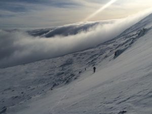
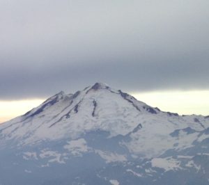
The classic Volcano of the North Cascades Mount Baker has the quality of routes like Rainier but without the altitude. The North Ridge of Mount Baker is a quality route with The Coleman-Demming an interesting glacier climb. The Easton is a more monotonous glacier route but is a good introduction to glaciated mountaineering. The Park and Cockscomb routes are more remote and more rarely done.
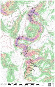
Routes on a glaciated peaks like Baker can vary greatly by the time of year. With good snow cover one can travel nearly anywhere without too much trouble from crevasses, but in a leaner snowpack crevasses may completely block certain routes. You will note 3 approaches to the North Ridge. The lowest is one I have used with the bivy marked on the map in September in very lean snow years. The middle one I have descended in September once but it seems to be a pretty good bet for most late season attempts. The upper route is the more common line for earlier summer ascents but was always out of conditions when I was there.
As with all the other posts in this series of North Cascades Maps I have a KMZ, KML, GPX and PDF for you, the links are below. I should give you a warning, the routes below might have errors and does not replace good route finding skills. Use at your own risk.
KML
Mount Baker GPX (Some browsers add a .xml extension, delete the .xml leaving only the .gpx extension before saving) KMZ GeoPDF
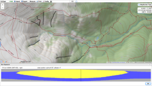
One of the important route planning skills for skiing is timing. In the winter we time for weather like wind so we can hit a run before the wind effects the snow. In spring however we time for sun exposure. Getting to the top of a run just prior to the sun hitting the slope so we can time the corn cycle. Even more important making sure we descend at the end of the day before the sun goes off the slope and turns the run into a scary icy slope are critical route planning objectives. Below is a little tutorial on how with Caltopo.com you can find out when the sun will hit.
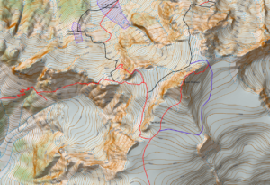
Next in the series of North Cascades maps is Shuksan. This complex mountain has a wide variety of routes from the straightforward Sulfide Glacier route to the classic mixed alpine route of the Fisher Chimneys and the steeper and remote North Face. The summit pyramid requires some rock scrambling up the South Gully but also has more difficult ridges on its Northeast side and beside the South Gully to the East (SE Ridge).
Shuksan also has a route that some of the AMGA groups have done from the White Salmon Glacier I am calling the Southwest Buttress although that may be an incorrect name. I have not found any info on the route online. I was involved in a course that did the route but I have not done it myself so the line may be off. I have also included the Sulfide Glacier Route as well and have not done that one either. All the other routes I have done numerous times.
You’ll note that there are two blue shaded sections near the base of the White Salmon Glacier. These sections have an overhead hazard from seracs. The larger one is quite serious since the seracs come from the Hanging Glacier high above. The smaller zone comes from a small barrier on the White Salmon itself.
I guess I should give you a warning, the routes below might have errors and does not replace good route finding skills. Use at your own risk.
Here is the .kml and .gpx files of the routes Shuksan.kml
Shuksan GPX (Some browsers add a .xml extension, delete the .xml leaving only the .gpx extension before saving)
I guess I should start with a warning, the routes below might have errors and does not replace good route finding skills. Use at your own risk.
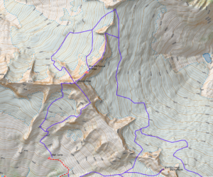
The Mount Forbidden area of the North Cascades is home to one of the 50 Classic Climbs of North America, the West Ridge. That by itself would make the area special but with Forbidden it is just the beginning. All the ridges are spectacular and arguably the North Ridge is as good or better particularly with the start up the Northwest Face of the North Ridge which adds an alpine ice face to a classic ridge. I have been fortunate to have climbed these routes many times over the years and that familiarity inspired me to make a map of the routes.
One route I never was able to do because of the time of year I was there was Mount Buckner’s North Face. I got to the base once but was turned around by weather. The route I have lined out is the one I had anticipated following since we had plans to do other routes in Boston Basin but I have not actually done that descent from Buckner. All the other routes I have done and replicated on the map using my memory and by overlaying the map on Google Earth and drawing in the routes.
For those that know how to import a GEOpdf into their phones here is a GEOpdf map. Forbidden Map
For those that would like to overlay the map onto Google Earth here is a KMZ file. Forbidden KMZ
For those who would like a KML or GPX file of the routes here they are.
Forbidden GPX (Some browsers add a .xml extension, delete the .xml leaving only the .gpx extension before saving) Forbidden KML
I guess I should start with a warning, the routes below might have errors and does not replace good route finding skills. Use at your own risk.
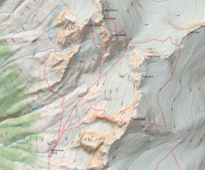
Over the years I have had the opportunity to climb a number of routes in the North Cascades teaching AMGA Advanced Alpine Guide Courses and Exams. One area that was particularly interesting was Mount Eldorado. By its normal route, the East Ridge it is an easy to moderate alpine peak. On the west side of the mountain however is the more remote Marble Basin. From the Marble Basin you can approach the West Arete of Eldorado, Southwest Face of Early Morning Spire, and the Southwest Buttress of Dorado Needle. These three routes alone make the area special but there are numerous other easier itineraries, in fact just getting into the Marble Basin is a worthwhile adventure.
I have put together a map of the routes I have used to approach, climb and descend the climbs in this area. For those that know how to import a GEOpdf into their phones here is a GEOpdf map. Eldorado Map
For those that would like to overlay the map onto Google Earth here is a KMZ file. Eldorado KMZ
For those who would like a KML or GPX file of the routes here they are
Eldorado GPX (Some browsers add a .xml extension, delete the .xml leaving only the .gpx extension before saving) Eldorado KML
I guess I should start with a warning, the plan below might have errors and does not replace good route finding skills. Use at your own risk.
At the beginning of this century I built a Haute Route Ski Tour plan that was passed around a lot amongst American Mountain Guides. Recently a guide asked me about it and that sparked me to modernize the “plan” using the new tools available. I wanted it to be editable for those with the knowledge to do that, simple for those who aren’t as knowledgeable and as accurate as I could possibly make it.
My first problem was that Swiss maps are problematic to use in digital form so I had to figure out a way to get good maps into Caltopo. That took awhile but I figured out a soulution albeit a bit inelegant. Once I had Swiss maps overlaid on Caltopo I created .KMZ files to overlay them on Google Earth. That allowed me with the help of the “Historical Imagery” under “View” to see ski tracks on much of the route. Using those tracks and my recollection of the route from having done it a number of times I drew in the route. I then imported the route with variations into Caltopo and made three Geopdf’s. By using only three that allows people to use the free version of Avenza PDF Maps for the entire trip and have the maps GPS enabled on your phone.
The three sections break out like this (click the link to open the GEOpdf)
So the pdf’s above can go into your phone into the Avenza app and you’ll have the maps GPS enabled on your phone with a blue dot where you are.
If you are more savvy and want to manipulate the data or download the tracks into a GPS device, below are the .GPX files
(Some browsers add a .xml extension, delete the .xml leaving only the .gpx extension before saving)
Once you get the maps into Google Earth you can adjust the opacity like this:
Finally if you want to overlay the Swiss maps onto Caltopo here is the Caltopo GeoJSON file. Once you import this file into Caltopo you’ll have the geospatial images in Caltopo. You should be in the vicinity of the Haute Route and using the TF Outdoors as the base map so you can easily locate the Geospatial Images. The GeoJSON file below imports all the Geospatial images for the three sections of the Haute Route.
Haute Route GeoJSON
(Some browsers add a .txt extension, delete the .txt leaving only the .json extension before saving)
This is the most modern, editable and simple system I could build. If you are new to these tools these files will be a good way to learn how to manipulate and build your own digital plans. I did this on a rest day while it was raining in March. Remember while you play with this data your not wasting time your doing your due diligence and planning for the Haute Route!
Imagine a person who had never seen anyone ski but had heard that skiing downhill was not only more efficient than walking, it was fun too. That person then got himself a pair of skis and went to the top of a ski area and tried skiing, again without any experience seeing someone ski. After many falls and struggles and likely long before reaching the bottom our imaginary person would be pretty convinced that skiing was not only inefficient but painful and no fun at all.
That story is an exaggeration of what I have seen about using skis to climb or as most call it skinning. Few people have had the benefit of seeing someone good at skiing uphill and there is a feedback loop that has happened that creates a false consensus that skinning is for nothing more than low angled trails in the woods. If you ever get to see large groups of people who are competent at skinning you would quickly realize steeper skinning isn’t inefficient you just have never seen it’s efficiency and haven’t worked at developing the technique.
Wow! I’m sure at this point some are offended but trust me that isn’t my goal. I really do not worry about people who would rather boot their way up a gully or run or belittle their opinion that they would rather boot. But if you want to take your backcountry skiing/ski mountaineering to the next level then understanding the importance of developing good uphill technique is likely your next step.
Let me continue with another story. When I first started skinning up to Tuckerman Ravine I was one of only a handful that skinned or used AT gear and heard over and over again how bad an idea it was. Now, on any given day I see nearly no one carrying his or her skis up to Hermit Lake. My experience in France seeing skiers skin allowed me back then to ignore what those in this area said but because, in the big scheme of things, I was only a beginner at skinning I wasn’t the best ambassador. Over time however people have seen more and more skinning and now it’s common on the trails.
The next step is taking that skill and increasing the steepness of the terrain you can skin and incorporating ski crampons. Given the type of snowpack and terrain we have here, ski crampons should be in the quiver of most of the people that ski in this area, yet they are rare. I have seen a few more people with ski crampons and using solid uphill kick turns and I am sure this will catch on. So if skiing in the mountains is your goal and you can turn’em going downhill, I would suggest working on these uphill skills:
1) Quick transitions of all types
Uphill to down hill
Putting your ski crampons in and out of your bindings
Skinning to booting
Booting to skinning
Downhill to uphill
2) Master the uphill kick turn
3) Incorporate ski crampons into your skinning 4) Learn to read terrain for the ascent
5) Learn the power of your lifters and their downside
6) Remember that you spend a lot of time climbing and take that into consideration when you choose your equipment. Skiing the heavy gear may seem to make sense to a skier used to lifts but buying the heavy stuff reduces your uphill ability. Think carefully about that weight to stiffness balance. Remember you may very well be a much better downhill skier than an uphill one so skiing down with lighter gear may be easier than pushing heavy gear up the hill.
I know people have seen my screen movies of maps overlaid onto Google Earth that are colorized so you can see how steep slopes are. Many have asked me how to do that and I do teach the process in my navigation course but the hardest part is creating a .kmz file. Once you have the .kmz file, opening it up in Google Earth is quite simple. Knowing that I did some research so I can put a .kmz file into my blog that you can download. Once downloaded you can easily open it up with Google Earth. I have included a short tutorial so that once you download the file you can have some fun with it in Google Earth. The file has map coverage of the entire Presidential Range. I hope you enjoy it. Download the .kmz file here. Make sure you have the latest version of Google Earth.
The Graham Ski Trail is an established trail but is not on any maps that I can find. Here is a map that has it as accurate as I could make it and should help you find it. It is easier to find from the Gulf of Slides Ski Trail but from the Sherburne Trail it may take a little looking to locate it as its entrance is a little camouflaged. Here is a link to a GeoPDF http://www.chauvinguides.com/wp-content/uploads/2017/01/graham.pdf
Below is the QR Code you can use to import the GeoPDF into Avenza Map App on your phone.
I am also including the
Graham Trail GPX (Some browsers add a .xml extension, delete the .xml leaving only the .gpx extension before saving) and .KML file of the trail.
My wife and I do a little ski touring. She does more than I do since winter is pretty busy for me but if we end up with a day off together we often will go out for a little XC Skiing. One area we go is Jackson Ski Touring, they have a wide variety of trails so we do some exploring of their trails. Of course I have made a Geopdf of their trail map so we can import it into the Avenza Map App on our phone. Since the map is all made I figured I would put it up here for anyone to have so you can use the trail map on your phone so that it is linked to your phone’s GPS so it will show you where you are on the map. Enjoy

 Ridge of Mount Baker is a quality route with The Coleman-Demming an interesting glacier climb. The Easton is a more monotonous glacier route but is a good introduction to glaciated mountaineering. The Park and Cockscomb routes are more remote and more rarely done.