Month: April 2017

Mount Baker

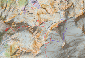
The classic Volcano of the North Cascades Mount Baker has the quality of routes like Rainier but without the altitude.  The North Ridge of Mount Baker is a quality route with The Coleman-Demming an interesting glacier climb.  The Easton is a more monotonous glacier route but is a good introduction to glaciated mountaineering.  The Park and Cockscomb routes are more remote and more rarely done.
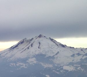
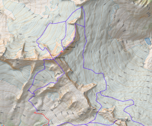
Routes on a glaciated peaks like Baker can vary greatly by the time of year.  With good snow cover one can travel nearly anywhere without too much trouble from crevasses, but in a leaner snowpack crevasses may completely block certain routes.  You will note 3 approaches to the North Ridge.  The lowest is one I have used with the bivy marked on the map in September in very lean snow years. The middle one I have descended in September once but it seems to be a pretty good bet for most late season attempts.  The upper route is the more common line  for earlier summer ascents but was always out of conditions when I was there.

As with all the other posts in this series of North Cascades Maps I have a KMZ, KML, GPX and PDF for you, the links are below. I should give you a warning, the routes below might have errors and does not replace good route finding skills. Use at your own risk.

KML
Mount Baker GPX (Some browsers add a .xml extension, delete the .xml leaving only the .gpx extension before saving)
KMZ
GeoPDF

Posted by Marc Chauvin in Mountain Biking

Measuring Sun Exposure

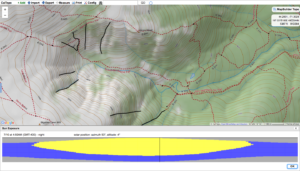
One of the important route planning skills for skiing is timing.  In the winter we time for weather like wind so we can hit a run before the wind effects the snow. In spring however we time for sun exposure.  Getting to the top of a run just prior to the sun hitting the slope so we can time the corn cycle. Even more important making sure we descend at the end of the day before the sun goes off the slope and turns the run into a scary icy slope are critical route planning objectives. Below is a little tutorial on how with Caltopo.com you can find out when the sun will hit.


Posted by Marc Chauvin in Mountain Biking

Shuksan

Next in the series of North Cascades maps is Shuksan.  This complex mountain has a wide variety of routes from the straightforward Sulfide Glacier route to the classic mixed alpine route of the Fisher Chimneys and the steeper and remote North Face.  The summit pyramid requires  some rock scrambling up the South Gully but also has more difficult ridges on its Northeast side and beside the South Gully to the East (SE Ridge).

Shuksan also has a route that some of the AMGA groups have done from the White Salmon Glacier I am calling the Southwest Buttress although that may be an incorrect name. I have not found any info on the route online.  I was involved in a course that did the route but I have not done it myself so the line may be off.  I have also included the Sulfide Glacier Route as well and have not done that one either.  All the other routes I have done numerous times.

You’ll note that there are two blue shaded sections near the base of the White Salmon Glacier.  These sections have an overhead hazard from seracs.  The larger one is quite serious since the seracs come from the Hanging Glacier high above.  The smaller zone comes from a small barrier on the White Salmon itself.

I guess I should give you a warning, the routes below might have errors and does not replace good route finding skills. Use at your own risk.

Here is the Geopdf map
Shuksan

Here is the .KMZ file
Shuksan.kmz

Here is the .kml and .gpx files of the routes
Shuksan.kml
Shuksan GPX (Some browsers add a .xml extension, delete the .xml leaving only the .gpx extension before saving)


Posted by Marc Chauvin in Mountain Biking

Forbidden

I guess I should start with a warning, the routes below might have errors and does not replace good route finding skills. Use at your own risk.

The Mount Forbidden area of the North Cascades is home to one of the 50 Classic Climbs of North America, the West Ridge. That by itself would make the area special but with Forbidden it is just the beginning. All the ridges are spectacular and arguably the North Ridge is as good or better particularly with the start up the Northwest Face of the North Ridge which adds an alpine ice face to a classic ridge.  I have been fortunate to have climbed these routes many times over the years and that familiarity inspired me to make a map of the routes.

One route I never was able to do because of the time of year I was there was Mount Buckner’s North Face.  I got to the base once but was turned around by weather.  The route I have lined out is the one I had anticipated following since we had plans to do other routes in Boston Basin but I have not actually done that descent from Buckner.  All the other routes I have done and replicated on the map using my memory and by overlaying the map on Google Earth and drawing in the routes.

For those that know how to import a GEOpdf into their phones here is a GEOpdf  map.
Forbidden Map

For those that would like to overlay the map onto Google Earth here is a KMZ file.
Forbidden KMZ

For those who would like a KML or GPX file of the routes here they are.
Forbidden GPX (Some browsers add a .xml extension, delete the .xml leaving only the .gpx extension before saving)
Forbidden KML

I hope you enjoy the map and data.

Posted by Marc Chauvin in Climbing and Avalanche Education