
I know people have seen my screen movies of maps overlaid onto Google Earth that are colorized so you can see how steep slopes 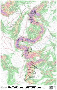 are. Many have asked me how to do that and I do teach the process in my navigation course but the hardest part is creating a .kmz file. Once you have the .kmz file, opening it up in Google Earth is quite simple. Knowing that I did some research so I can put a .kmz file into my blog that you can download. Once downloaded you can easily open it up with Google Earth. I have included a short tutorial so that once you download the file you can have some fun with it in Google Earth. The file has map coverage of the entire Presidential Range. I hope you enjoy it. Download the .kmz file here.
Make sure you have the latest version of Google Earth.
- 0-20 Degrees White
- 21-25 Degrees Light Green
- 26-30 Degrees Dark Green
- 31-35 Degrees Yellow
- 36-40 Degrees Red
- 41-45 Degrees Purple
- 46-50 Degrees Blue
- 51-90 Degrees Black
Here is a little tutorial