
Figure of 8: Pushing the Mountain Run
Wednesday May 27, 2009
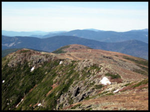
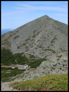
 Many have heard of the Pemi Loop here in the White Mountains and it has become the signature long trail run/speed hike in the White Mountains. The Pemi Loop is just over 30 miles and it has an elevation gain and loss of about 9100 feet The thing about the Pemi Loop is that it does not go over the signature range in the White Mountains, the Presidentials! The long hike/run in the Presidentials tends to be and end to end hike that requires two cars and the logistic of a car spot. What I wanted was a loop hike like the Pemi Loop with the same kind of distance and elevation gain and included the majority of the Presidentials, what I came up with was the Presidential Figure of Eight. The reason I call it the Figure of Eight is because of the shape of the route when drawn on a map. The route starts at the AMC Pinkham Notch Camp and climbs via the Tuckerman Ravine Trail across the Bigelow Lawn to Lakes of the Clouds Hut. From there it continues down the Crawford Path and Webster Cliff Trail to Mizpah Hut. From Mizpah the “eight” goes down the Mount Clinton and Dry River Cut-Off trails to the Dry River trail and follows that up the Dry River and Oakes Gulf back up to the Lakes of the Clouds Hut. From there it goes up the Crawford Path towards Mount Washington to the Westside Trail and onto the Gulfside Trail. The Gulside trail is then followed all the way to Mount Madison then down the Osgood and Osgood Cut-Off to the Madison Gulf Trail then on to the Old Jackson Road back to Pinkham. The Presidential Figure of Eight Loop is 30.6 miles long with an elevation change of 10,000 feet. Here is a PDF Map of the route with hour splits, the red line sections are the sections I was able to run while the blue line sections are where I did some speed hiking, it is best viewed at 150%. Figure of Eight Map.
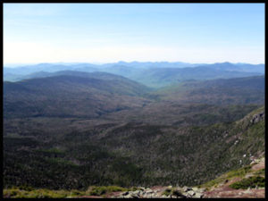
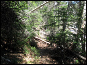
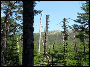
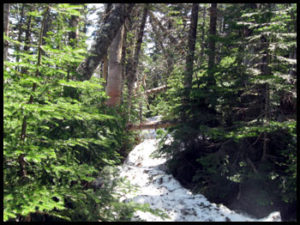
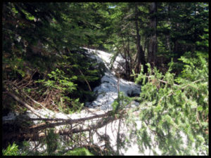
The trip started well all the way to Mizpah Hut, the Southern Presidentials and in particular the Crawford Path has to be some of the best high mountain trail running in the White Mountains. Things started to change as I descended down into the Dry River. The trail is rough and the long winter had taken its toll with mud, debris and blowdowns. The conditions worsened as I descended to and made my way up the Dry River. About 2 miles away from Lakes of the Clouds Hut I started to run into snow, I had expected some snow on the trails but I was surprised by how much was still on the Dry River Trail. There were sections of postholing and a few times it was difficult to find the trail. The Dry River section took far more time than I had planned adding about 1 hour to my estimate. Once I broke treeline the trail cleared out and I was able to keep to a more consistent pace. I was feeling pretty good all the way to Madison Hut, the climb up from the Madison Hut to the summit of Mount Madison however felt very hard. I was able to run down from the summit of Madison all the way to the Madison Gulf Trail but it was a very stiff labored run. When I hit the 2 mile section of the Madison Gulf Trail up to the Mount Washington Auto Road the slight uphill of that trail made it impossible for me to run. I was able to eeek out a run for the final section down the Old Jackson Road.
Here are the statistics;
| Trails: | Tuckerman Ravine, Lion’s Head, Alpine Garden, Tuckerman Crossover, Crawford, Mount Clinton, Dry River Cut-Off, Dry River, Crawford, Westside, Gulfside, Osgood, Osgood Cutoff, Madison Gulf, Old Jackson Road, , |
| Type of Trip: | Figure of Eight Loop |
| Distance: | 30.6 |
| Elevation Gain and Loss: | 10,000 Feet |
| Time: | 11 Hours 38 Minutes |
 |
|
The Pack |
To give you an idea of what I wore and carried here is a list;
This is what I wore all day;
EMS Techwick Short Sleeve T-Shirt
Patagonia Running Tights (no longer available)
LaSportiva Wildcat Trail Running Shoe
Julbo Sunglasses
This is what I carried;
1.5 Liter Camelback Water Bladder
Marmot Driclime Windshirt
Pearl Izumi Cyclone Gloves
Buff
Petzl E Lite
Cell Phone
MP3 Player
Lighter
Roll of Athletic Tape
This is what I had for food;
3 Snickers Bars
9oz of Trail Mix
5-Hour Energy
Here are the conditions on the summit of Mount Washington during the day;
|
Time
|
Temperature Degrees F
|
Wind
|
|
8 AM
|
32
|
NNW 23
|
|
9 AM |
33
|
NNW 22
|
|
10 AM
|
33
|
NNW 17
|
|
11 AM
|
35
|
Variable 5
|
|
NOON
|
37
|
Variable 7
|
|
1 PM
|
39
|
W 8
|
|
2 PM
|
41
|
WNW 14
|
|
3 PM
|
41
|
W 16
|
|
4 PM
|
42
|
W 12
|
|
5 PM
|
41
|
W14
|
|
6 PM
|
41
|
WNW 15
|
|
7 PM
|
41
|
W 12
|
|
8 PM
|
37
|
W 10
|
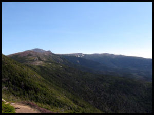
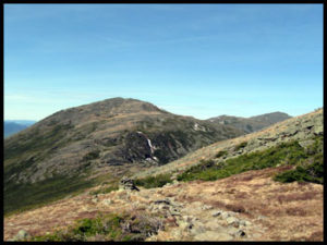
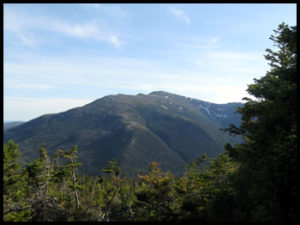
 Quality views and awesome running in the Southern Presidentials |
|
|
|
|
|
|
|

|
|
|
|
|
|
|
|
|
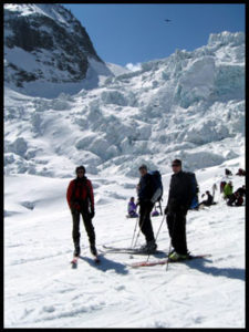 Whenever I haven’t written in my blog for awhile I find it difficult to get started writing one. Often it is not because I don’t have anything to write about it’s usually because too much has gone on and I feel daunted trying to write it all down. For instance my last entry was posted in the middle of March. Since then I’ve ice climbed with Hakan and Mike who were training for Rainier, I climbed with Ed and his grandson for two days, I I taught two 4 day AIARE Level II Avalanches Courses, got to climb with Harold who has been coming up to climb at the end of March for as long as I can remember and I got to climb with Jacky and Tim. That list ended my March. At the start of April I left for Chamonix to do some ski tours, I had scheduled two Chamonix-Zermatt Haute Routes, the first with Ryan, Mike and David the second Haute Route was with Joe, Cameron and Tom.


