
Avalanche Forecast for Wednesday, March 27, 2019
This information was published 03/27/2019 at 7:12 AM.
A new forecast will be issued tomorrow.

The Bottom Line
Small wind slabs formed early in the week have become unlikely, but not impossible for a person to trigger. This is especially true where you find softer pockets of new snow that managed to escape the effect of the wind. With much of our snow pack firm and smooth, triggering a small wind slab could result in a consequential fall in steep terrain. Large, firm wind slabs formed this past weekend have gained strength and are also unlikely to avalanche, though still worthy of respect where you find terrain roll-overs: mid level in Oaks Gulf as an example. All forecast areas have LOW avalanche danger today with the exception of the Headwall in Tuckerman Ravine at MODERATE where you may find larger, thicker wind slabs formed from the recent new snow.
Mountain Weather
Blue skies yesterday were accompanied by 50-60 mph NW wind and cold temperatures with the summit barely breaking into the single digits F. Today, we are welcoming another day of blue skies, this time with warmer temperatures and less wind. The summit should reach into the upper teens F with W wind at 15-30 mph. Tomorrow, a southwesterly flow of warmer air will push summit temperatures into the upper 20’s F, higher wind speeds and increasing clouds. The next chance for precipitation is expected tomorrow night with the possibility for 1-3” of mixed snow/sleet.
Primary Avalanche Problem – Wind Slab
Wind Slab
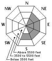
Aspect/Elevation
Likelihood
Size
One to two inches of new snow Sunday night at at upper elevations followed by 48 hours of strong westerly wind have created wind slabs on the east side of the range that are generally firm and unreactive. Wind sheltered terrain may contain small pockets of softer wind slabs that will be more stubborn than reactive, though these are limited in size and thickness. Large wind slabs formed Friday & Saturday have gained stability since the natural avalanche cycle and have since been unreactive to human triggers. Keep these hard slabs on your radar, particularly on steep, convex terrain features or over a thin spot in the slab.
What is a Windslab Avalanche?
![]() Wind Slab avalanches are the release of a cohesive layer of snow (a slab) formed by the wind. Wind typically transports snow from the upwind sides of terrain features and deposits snow on the downwind side. Wind slabs are often smooth and rounded and sometimes sound hollow, and can range from soft to hard. Wind slabs that form over a persistent weak layer (surface hoar, depth hoar, or near-surface facets) may be termed Persistent Slabs or may develop into Persistent Slabs.
Wind Slab avalanches are the release of a cohesive layer of snow (a slab) formed by the wind. Wind typically transports snow from the upwind sides of terrain features and deposits snow on the downwind side. Wind slabs are often smooth and rounded and sometimes sound hollow, and can range from soft to hard. Wind slabs that form over a persistent weak layer (surface hoar, depth hoar, or near-surface facets) may be termed Persistent Slabs or may develop into Persistent Slabs.
Forecast Discussion
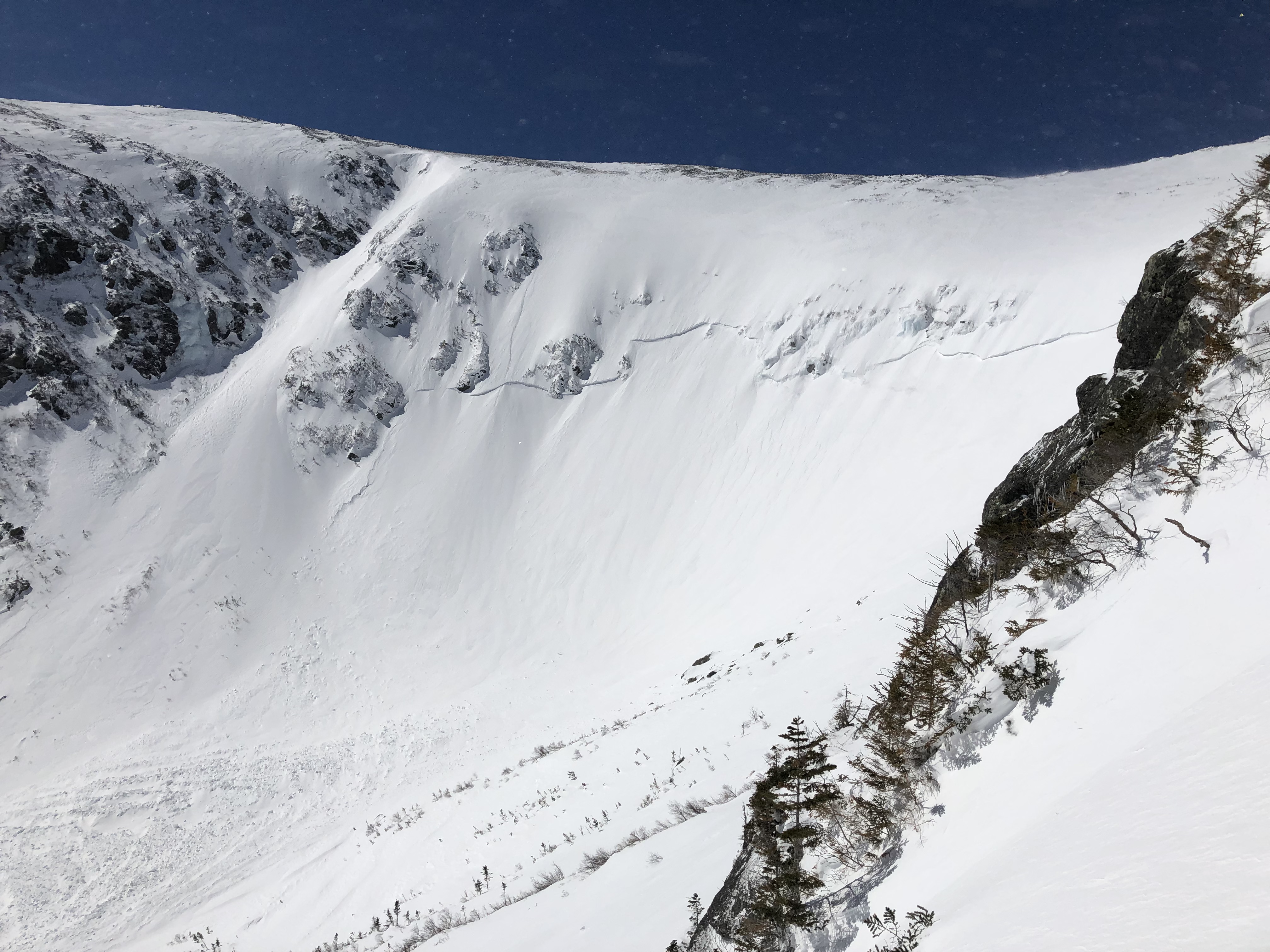
Tuckerman Ravine Headwall 3/26/2019
Just 5 days ago 20” of snow fell at higher elevations. Under increasing 50-70 mph winds, the new snow formed dangerous storm and wind slabs and elevated our avalanche danger to Considerable and High. The new snow resulted in two natural avalanche cycles in the Headwall of Tuckerman Ravine and the Gulf of Slides with no other natural activity observed or reported. The elevated danger was short lived as several hours of intense NW wind late Saturday afternoon resulted in heavy scouring in some locations with stubborn wind slab elsewhere by Sunday morning. The firm (P & 1F) wind slab could be found to be several feet thick in some locations with little energy to crack and propagate. Human triggers are unlikely to trigger an avalanche in these older wind slabs.
The roughly 2” of new snow that fell Sunday night was also impacted by several hours of 60-70 mph W wind, scouring and forming 1F to 4F wind slabs not observed at more than a foot thick. These new wind slabs appear to be well bonded to the existing snow pack. Today, we are at the start of what could be a spell of significant warming which may negatively affect the snow pack in next couple of days, especially at lower elevations. It has been a busy week!
Additional Information
The Sherburne and Gulf of Slides ski trails are snow covered to Pinkham Notch.
Details on daily snowfall totals, precipitation type, total depth of snow and other information can be found on our page devoted to snow study plot data. Click here to check it out.
Recent snowpack and avalanche observations can be found here and on Instagram. Your observations help improve our forecast product. Please take a moment and submit a photo or two and a brief description of snow and avalanche information that you gather in the field.
Snow Plot Information
| Date | HN24 | HN24W (SWE) | Density (%) | HST | Total | Air T | T Max | T Min | Sky | Precip | Comments |
|---|---|---|---|---|---|---|---|---|---|---|---|
| 04/13/20 06:15 | 0 CM | 0.1 MM | 0CM | 206 CM | -3.5 C | 7.5 C | -7.0 C | Overcast | Rain | ||
| 04/12/20 06:20 | Trace | 1.8 MM | Trace | 216 CM | -7.0 C | -4.0 C | -7.0 C | Few | No precipitation | ||
| 04/11/20 06:20 | 14 CM | 23.1 MM | 14% | 62CM | 222 CM | -8.0 C | -6.0 C | -8.0 C | Overcast | No precipitation | |
| 04/10/20 06:30 | 53 CM | 49.5 MM | 12% | NC | 200 CM | -6.0 C | -2.0 C | -6.5 C | Overcast | Snow | View |
| 04/09/20 06:25 | 0 CM | 0.0 MM | 0CM | 158 CM | -1.0 C | 8.0 C | -4.5 C | Clear | No precipitation |
Avalanche Log and Summit Weather
Thank you Mount Washington Observatory for providing daily weather data from the summit of Mount Washington.
| Date | Max Temp | Min Temp | Total (SWE) | 24H Snow & Ice | Wind Avg | Wind Fastest Mile | Fastest Mile Dir | Avalanche Activity |
|---|---|---|---|---|---|---|---|---|
| 05/25/20 | 54 F | 46 F | 0.0 in | 0.0 in | 18.7 MPH | 44 MPH |
260 (W) | |
| 05/24/20 | 54 F | 40 F | 8.3 in | 21 in | 8.3 MPH | 21 MPH |
280 (W) | |
| 05/23/20 | 55 F | 43 F | 0.0 in | 0.0 in | 15 MPH | 45 MPH |
300 (WNW) | |
| 05/22/20 | 55 F | 40 F | 0.0 in | 0.0 in | 37.4 MPH | 67 MPH |
290 (WNW) | |
| 05/21/20 | 53 F | 38 F | 0.0 in | 0.0 in | 29.4 MPH | 59 MPH |
280 (W) | |
| 05/20/20 | 50 F | 34 F | 0.0 in | 0.0 in | 29.4 MPH | 59 MPH |
280 (W) | |
| 05/19/20 | 41 F | 27 F | 0.0 in | 0.0 in | 15.3 MPH | 36 MPH |
100 (E) | |
| 05/19/20 | 50 F | 34 F | 0.0 in | 0.0 in | 11.4 MPH | 25 MPH |
30 (NNE) | |
| 05/18/20 | 45 F | 30 F | 0.0 in | 0.0 in | 14.7 MPH | 36 MPH |
70 (ENE) | |
| 05/17/20 | 40 F | 30 F | 0.0 in | 0.0 in | 17 MPH | 35 MPH |
270 (W) | |
| 05/16/20 | 37 F | 28 F | .16 in | 0.0 in | 38.8 MPH | 101 MPH |
310 (NW) | |
| 05/15/20 | 42 F | 32 F | .95 in | Trace | 31.5 MPH | 95 MPH |
250 (WSW) |
Please Remember:
Safe travel in avalanche terrain requires training and experience. This forecast is just one tool to help you make your own decisions in avalanche terrain. You control your own risk by choosing where, when, and how you travel.
Avalanche danger may change when actual weather differs from the higher summits forecast.
For more information contact the US Forest Service Snow Rangers, AMC visitor services staff at the Pinkham Notch Visitor Center, or the caretakers at Hermit Lake Shelters or seasonally at the Harvard Cabin (generally December 1 through March 31). The Mount Washington Ski Patrol is also available on spring weekends.
Posted 03/27/2019 at 7:12 AM.
Jeff Fongemie, Snow Ranger
USDA Forest Service
White Mountain National Forest
Send us Your Observations
INCIDENTS & ACCIDENTS
 The Mount Washington Avalanche Center is a partnership between the White Mountain National Forest, White Mountain Avalanche Education Foundation and Friends of Tuckerman Ravine and other community organizations. The avalanche forecast applies only to backcountry areas, not operating ski areas, and describes general avalanche conditions which vary locally. The avalanche information provided is the sole responsibility of the USDA Forest Service.