
Avalanche Forecast for Thursday, March 28, 2019
This information was published 03/28/2019 at 7:05 AM.
A new forecast will be issued tomorrow.

The Bottom Line
We are starting the day with LOW avalanche danger in all forecast areas. Generally unreactive wind slabs in the terrain have had time to settle and strengthen but will be subjected to some heating today. Cold, dry, chalky slabs on shady mid elevation slopes may survive the warm-up today but sunny aspects are likely to soften in the sun this morning. Remember that softening of a firm wind slab equals weakening so keep your guard up and manage your exposure to this hazard. As this heating occurs, the potential to trigger a larger slab may push the avalanche danger to MODERATE on sunny or warm aspects and elevations.
Mountain Weather
Temperatures rose yesterday in the full sunshine to above the freezing mark at Ravine elevations. The air temperature on the summit reached a high of 18F by late afternoon where it remained overnight and will rise further to the mid-20s today. The current temperature at Gray Knob is 24F, at Harvard Cabin, 30F with 28F at 4,000’ on the Auto Road. Expect partly cloudy skies by noon to increase in coverage through the day. Summit wind is currently from the west-southwest at around 40 mph which will shift a bit to the west and increase slowly through the day, reaching the 40-55 mph range by nightfall as clouds fill the sky. Light precipitation arrives tonight with an inch of snow up high and rain at lower elevations.
Primary Avalanche Problem – Wind Slab
Wind Slab
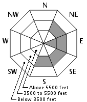
Aspect/Elevation
Likelihood
Size
The two main wind slab types in avalanche terrain will be subjected to limited warming today. Softer wind slabs will respond first to any warming that occurs today though these slabs are isolated. Firmer wind slabs may soften a bit further than yesterday on the surface which could weaken their bridging power over any lingering weak layer. Human-triggering of these slabs hinges on the degree of warming that occurs today.
What is a Windslab Avalanche?
![]() Wind Slab avalanches are the release of a cohesive layer of snow (a slab) formed by the wind. Wind typically transports snow from the upwind sides of terrain features and deposits snow on the downwind side. Wind slabs are often smooth and rounded and sometimes sound hollow, and can range from soft to hard. Wind slabs that form over a persistent weak layer (surface hoar, depth hoar, or near-surface facets) may be termed Persistent Slabs or may develop into Persistent Slabs.
Wind Slab avalanches are the release of a cohesive layer of snow (a slab) formed by the wind. Wind typically transports snow from the upwind sides of terrain features and deposits snow on the downwind side. Wind slabs are often smooth and rounded and sometimes sound hollow, and can range from soft to hard. Wind slabs that form over a persistent weak layer (surface hoar, depth hoar, or near-surface facets) may be termed Persistent Slabs or may develop into Persistent Slabs.
Secondary Avalanche Problem – Wet Loose
Wet Loose
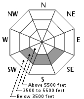
Aspect/Elevation
Likelihood
Size
Lower elevation slopes have been heated already this week and don’t contain much other than small, unreactive slabs on otherwise mostly refrozen snow. Temperatures will push above freezing quickly this morning. Webster cliff gullies with enough snow in them could have this problem. Loose wet activity on larger mid elevation slopes and gullies should be easily manageable.
What is a Wet Loose Avalanche?
![]() Wet Loose avalanches are the release of wet unconsolidated snow or slush. These avalanches typically occur within layers of wet snow near the surface of the snowpack, but they may quickly gouge into lower snowpack layers. Like Loose Dry Avalanches, they start at a point and entrain snow as they move downhill, forming a fan-shaped avalanche. Other names for loose-wet avalanches include point-release avalanches or sluffs. Loose Wet avalanches can trigger slab avalanches that break into deeper snow layers.
Wet Loose avalanches are the release of wet unconsolidated snow or slush. These avalanches typically occur within layers of wet snow near the surface of the snowpack, but they may quickly gouge into lower snowpack layers. Like Loose Dry Avalanches, they start at a point and entrain snow as they move downhill, forming a fan-shaped avalanche. Other names for loose-wet avalanches include point-release avalanches or sluffs. Loose Wet avalanches can trigger slab avalanches that break into deeper snow layers.
Forecast Discussion
Instability caused by warming can occur quickly. Competing weather factors today make pinning down the rate of warming difficult. Increasing cloud cover can provide shade on a slope but can also reflect enough radiation to create a greenhouse effect if the cloud cover is thin. The prevailing opinion among forecasters this morning is that heating won’t be enough to wet the slabs to create a wet avalanche problem but the limited warming that we will see today is enough to raise doubts about the reliability of large slabs that remain in the terrain following last weekend’s avalanche cycle. The areas of most concern for this to occur would be in the hangfire in Sluice and Lip in Tuckerman Ravine as well as in Oakes Gulf or similar slopes. Though it’s a remote risk, it pays to increase your margin by limiting your time spent on or under these slopes…booting up a lower angle or shady line will reduce your chance of triggering the slope even further.
Snow Plot Information
| Date | HN24 | HN24W (SWE) | Density (%) | HST | Total | Air T | T Max | T Min | Sky | Precip | Comments |
|---|---|---|---|---|---|---|---|---|---|---|---|
| 04/13/20 06:15 | 0 CM | 0.1 MM | 0CM | 206 CM | -3.5 C | 7.5 C | -7.0 C | Overcast | Rain | ||
| 04/12/20 06:20 | Trace | 1.8 MM | Trace | 216 CM | -7.0 C | -4.0 C | -7.0 C | Few | No precipitation | ||
| 04/11/20 06:20 | 14 CM | 23.1 MM | 14% | 62CM | 222 CM | -8.0 C | -6.0 C | -8.0 C | Overcast | No precipitation | |
| 04/10/20 06:30 | 53 CM | 49.5 MM | 12% | NC | 200 CM | -6.0 C | -2.0 C | -6.5 C | Overcast | Snow | View |
| 04/09/20 06:25 | 0 CM | 0.0 MM | 0CM | 158 CM | -1.0 C | 8.0 C | -4.5 C | Clear | No precipitation |
Avalanche Log and Summit Weather
Thank you Mount Washington Observatory for providing daily weather data from the summit of Mount Washington.
| Date | Max Temp | Min Temp | Total (SWE) | 24H Snow & Ice | Wind Avg | Wind Fastest Mile | Fastest Mile Dir | Avalanche Activity |
|---|---|---|---|---|---|---|---|---|
| 05/25/20 | 54 F | 46 F | 0.0 in | 0.0 in | 18.7 MPH | 44 MPH |
260 (W) | |
| 05/24/20 | 54 F | 40 F | 8.3 in | 21 in | 8.3 MPH | 21 MPH |
280 (W) | |
| 05/23/20 | 55 F | 43 F | 0.0 in | 0.0 in | 15 MPH | 45 MPH |
300 (WNW) | |
| 05/22/20 | 55 F | 40 F | 0.0 in | 0.0 in | 37.4 MPH | 67 MPH |
290 (WNW) | |
| 05/21/20 | 53 F | 38 F | 0.0 in | 0.0 in | 29.4 MPH | 59 MPH |
280 (W) | |
| 05/20/20 | 50 F | 34 F | 0.0 in | 0.0 in | 29.4 MPH | 59 MPH |
280 (W) | |
| 05/19/20 | 41 F | 27 F | 0.0 in | 0.0 in | 15.3 MPH | 36 MPH |
100 (E) | |
| 05/19/20 | 50 F | 34 F | 0.0 in | 0.0 in | 11.4 MPH | 25 MPH |
30 (NNE) | |
| 05/18/20 | 45 F | 30 F | 0.0 in | 0.0 in | 14.7 MPH | 36 MPH |
70 (ENE) | |
| 05/17/20 | 40 F | 30 F | 0.0 in | 0.0 in | 17 MPH | 35 MPH |
270 (W) | |
| 05/16/20 | 37 F | 28 F | .16 in | 0.0 in | 38.8 MPH | 101 MPH |
310 (NW) | |
| 05/15/20 | 42 F | 32 F | .95 in | Trace | 31.5 MPH | 95 MPH |
250 (WSW) |
Please Remember:
Safe travel in avalanche terrain requires training and experience. This forecast is just one tool to help you make your own decisions in avalanche terrain. You control your own risk by choosing where, when, and how you travel.
Avalanche danger may change when actual weather differs from the higher summits forecast.
For more information contact the US Forest Service Snow Rangers, AMC visitor services staff at the Pinkham Notch Visitor Center, or the caretakers at Hermit Lake Shelters or seasonally at the Harvard Cabin (generally December 1 through March 31). The Mount Washington Ski Patrol is also available on spring weekends.
Posted 03/28/2019 at 7:05 AM.
Frank Carus
USDA Forest Service
White Mountain National Forest
Send us Your Observations
INCIDENTS & ACCIDENTS
 The Mount Washington Avalanche Center is a partnership between the White Mountain National Forest, White Mountain Avalanche Education Foundation and Friends of Tuckerman Ravine and other community organizations. The avalanche forecast applies only to backcountry areas, not operating ski areas, and describes general avalanche conditions which vary locally. The avalanche information provided is the sole responsibility of the USDA Forest Service.