
I guess I should start with a warning, the routes below might have errors and does not replace good route finding skills. Use at your own risk.
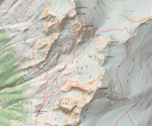 Over the years I have had the opportunity to climb a number of routes in the North Cascades teaching AMGA Advanced Alpine Guide Courses and Exams. One area that was particularly interesting was Mount Eldorado. By its normal route, the East Ridge it is an easy to moderate alpine peak. On the west side of the mountain however is the more remote Marble Basin. From the Marble Basin you can approach the West Arete of Eldorado, Southwest Face of Early Morning Spire, and the Southwest Buttress of Dorado Needle. These three routes alone make the area special but there are numerous other easier itineraries, in fact just getting into the Marble Basin is a worthwhile adventure.
I have put together a map of the routes I have used to approach, climb and descend the climbs in this area. For those that know how to import a GEOpdf into their phones here is a GEOpdf map.
Eldorado Map
For those that would like to overlay the map onto Google Earth here is a KMZ file.
Eldorado KMZ
For those who would like a KML or GPX file of the routes here they are
Eldorado GPX (Some browsers add a .xml extension, delete the .xml leaving only the .gpx extension before saving)
Eldorado KML
I hope you enjoy the map and data.