Mountain Biking

Gran Paradiso Map and KMZ

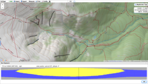
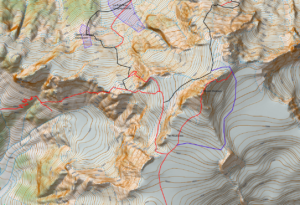
In my previous post I had a video explaining how I was working on a Gran Paradiso map and putting it on an offsite server so it can put it into Caltopo as a map layer to manipulate. Well that process has been completed and I have been working the map a bit more. That process got me to realize that for some the process of importing the map, hill shading and slope shade into Caltopo so they can be manipulated may be to0 techie . For that reason I felt publishing maps that are ready for use in Avenza might be useful. In this post I have linked a typical contour map, a slope shaded map and a .kmz file that you can use. The .kmz file will download onto your computer and when clicked on will overlay the map onto Google Earth. If you are comfortable with Caltopo and would like to import the map, hill shade and slope shade into Caltopo e mail me at marc@chauvinguides.com and I will e mail you the server address and basic instructions to add them as “Custom Layers” in Caltopo.

Here is the link to the Geopdf.
http://www.chauvinguides.com/wp-content/uploads/2018/03/paradiso.pdf

Here is the link to the Slope Shaded –the slope angle key is on the upper right had corner.
http://www.chauvinguides.com/wp-content/uploads/2018/03/paradisoslope.pdf

Here is the link to the .kmz file.
http://www.chauvinguides.com/wp-content/uploads/2018/03/paradiso.kmz


Posted by Marc Chauvin in Mountain Biking

Hokkaido Niseko Area Including Yotei

This is a rare type of post for me. I have a number of friends heading to Japan to ski or ski guide and since I needed projects to lean how to build maps I decided I would make some maps for Japan. What makes that rare is I have never been to Japan to ski or otherwise–in transit at the airport not withstanding. The maps are slope shaded with the slope key in the bottom corner of the map.

If you are about to head to Japan I hope you find the maps useful. If you use the QR code to get the Geopdf map into Avenza on your phone they will work for as long as this website is up. I would recommend you download the maps and transfer them into Avenza on your phone via iTunes that way you can get them in if you do not have an internet connection.

North of Niseko

SW of Niseko

E of Niseko Yotei

KMZ File  Download and click to open the maps in Google Earth


Posted by Marc Chauvin in Mountain Biking

New Caltopo Layer Patagonia

New Caltopo Layer Patagonia

For those that are wondering what I’ve been working on this is how you can use my maps on Caltopo now that I have a WMS server

If you want to make a .KMZ file from the layer make your base layer TF Outdoors then Stack the Custom Layer (Patagonia) at 100% over that, otherwise you’ll get an error.

Here is the link you need to paste into Caltopo that I mention in the video.

http://45.63.67.37:8080/geoserver/Patagonia/wms?SERVICE=WMS&?SERVICE=WMS&VERSION=1.1.1&REQUEST=GetMap&STYLES=&BBOX={left},{bottom},{right},{top}&WIDTH={tilesize}&HEIGHT={tilesize}&BGCOLOR=0xCCCCCC&FORMAT=image/png&EXCEPTIONS=application/vnd.ogc.se_inimage&SRS=EPSG:3857&LAYERS=PatagoniaforGE


Posted by Marc Chauvin in Maps, Mountain Biking

Gooseberry Mesa MTB

Gooseberry Mesa was my first ride on slickrock ride. The trailhead for the mesa is located just outside Hurricane UT about 2hr 45min from Las Vegas and 4hrs 45 min from Salt Lake City.  On the Mountain Bike Project website they say: “Gooseberry Mesa is 
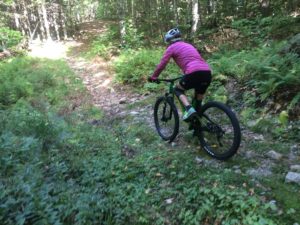
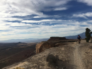
a world class trail. It’s one of the best technical trails anywhere with rolling slickrock, twisty singletrack, and vistas to die for.” With that kind of description we had to go there and do some riding.

My trip started with a flight to Salt Lake City for an American Mountain Guide Association meeting. There I met with Rob Coppolillo and after the meeting we drove to the trailhead. We started the ride just after 3pm, pretty late for October 30th. So Rob and I started by doing the South Rim Trail then Hidden Canyon finally the Secret Trail back to the car. The ride we did was 17.5 miles long which took us 3hrs and 45 min to complete. We finished the last 20 minutes by headlamp.

The riding was cross country style and although there isn’t any real up or down the trails go over rough rolling terrain so there are short technical ups and downs throughout the ride. Instead of trying to describe the riding here are a few videos to give you a taste.

As per usual here is the geopdf map, gpx, and kml file so you can have the navigation info for the area. The map is is from utahmountainbiking.com and I geo referenced it onto Caltopo so you can import it into Avenza and have it sync with your phones gps and you’ll get a blue dot at your location.

Gooseberry Map 

Gooseberry Map KMZ

Gooseberry GPX of our ride
(Some browsers add a .xml extension, delete the .xml leaving only the .gpx extension before saving)
Gooseberry KML of our ride


Posted by Marc Chauvin in Maps, Mountain Biking

Cliff Area MBT Trails

Cathedral and Whitehorse are both known for rock climbing but they are also a centerpiece of the mountain bike trails in that area.  Good cross country, nice downhills, technical uphills and great views make this area a fun and interesting place to ride.  You’ll notice a high density of trails around Echo Lake.  As far as I know all the trails are open to mountain biking but some have been particularly built for biking while others are old dirt roads and hiking trails.  The maze of trails there were difficult to map and take an inventory of.  Because of the density expect to be a little confused at times, some are so close together the gps may not be able to distinguish which one you are on.  They are as accurate as I could make them.

Again the White Mountain chapter of NEMBA has done a lot of work here so please support them any way you can.  You will notice on the southern end of the map one old dirt road (snowmobile trail) and a single track that head into the Marshall Property.  You can find a Marshall Property map here .

I hope you enjoy the map and the riding. The map is a Geopdf and will interface with the GPS in your phone if you use the Avenza App.
Click the photo below for the Cliff Area Map

Click to download the map

Posted by Marc Chauvin in Mountain Biking

Marshall Property Trails

The Marshall Conservation Area is Town Conservation Land that has been recently acquired. White Mountain Chapter of NEMBA has been quite busy building trails and upgrading and relocating older trails. Please assist them in any way you can WMMBA. My understanding is that there will be more work done over the next few years so the map below may start omitting trails or be in error.  The trails on this map were as accurate as I could make them as of late Fall 2016.  I will try to keep up with changes and update as often as possible.

The parking for the Marshall Property is 2.2 miles from the lights in Conway right where West Side Road crosses the railroad tracks. The Marshall Property’s Trails link nicely with the cliff area via the Mineral Mine Trailhead (shown on map) and the High School Loop Trail (not shown on map)  This means that for the most part you can ride single track trails from the Marshall Property to the Upper Stoney Trail that leads to the summit of Whitehorse.  With a bit more dirt road riding and double track (snowmobile trail) you can get roughly to the halfway point of the Cathedral Road giving access to the top of Cathedral. The map is a Geopdf and will interface with the GPS in your phone if you use the Avenza App. Click the photo below for the Marshall Property Map

Click to Download Map


Posted by Marc Chauvin in Mountain Biking

Thompson Road, Walmart and Outer Limits Area MTB Trails

Over the past few years I have started to mountain bike.  That new sport got me onto trails I never knew existed that were right in my backyard so to speak.  As I rode I would track myself so I could better make sense of the maze of trails I was riding. Those tracks would get imported into Caltopo and I started getting a good quality map of areas.  The Mount Washington Valley has numerous areas but can be broken up as East Side and West Side.  Those two sides can be further broken up into two sections each splitting the valley into quarters.  The West Side has the Marshal Property to the south and the cliff area to the north.  The East Side can be broken up by Black Cap area to the north and the Thompson/Walmart/Outer-limits area to the south.  This last area is the most dense area of trail and would make North Conway a special area for biking if it were the only place to bike.  For that reason it is the focus of this map.

Numerous maps exist but trails get relocated or new ones get built. As far as I have found this map is the most accurate and complete but expect some adventure.  NoCo biking is; low key, loosely organized and not overbuilt. In short it’s a great low key place to ride and people want to keep it that way.

Most if not all of the trails are built by the White Mountain Chapter of NEMBA and East Side Bike Guides and are free to use, please support them any way you can. You can also find more maps here   The trails on the map below cross; town, state and private conservation land.  Please be respectful of closures and trails that are hiking only.  Mountain biking is well accepted and the areas that are closed are few and for good reason.

The map is a Geopdf and will interface with the GPS in your phone if you use the Avenza App.
Click the photo below for the Thompson Rd, Walmart, Outerlimits Map

Click to Download the Map


Posted by Marc Chauvin in Mountain Biking

Mount Baker

The classic Volcano of the North Cascades Mount Baker has the quality of routes like Rainier but without the altitude.  The North Ridge of Mount Baker is a quality route with The Coleman-Demming an interesting glacier climb.  The Easton is a more monotonous glacier route but is a good introduction to glaciated mountaineering.  The Park and Cockscomb routes are more remote and more rarely done.

Routes on a glaciated peaks like Baker can vary greatly by the time of year.  With good snow cover one can travel nearly anywhere without too much trouble from crevasses, but in a leaner snowpack crevasses may completely block certain routes.  You will note 3 approaches to the North Ridge.  The lowest is one I have used with the bivy marked on the map in September in very lean snow years. The middle one I have descended in September once but it seems to be a pretty good bet for most late season attempts.  The upper route is the more common line  for earlier summer ascents but was always out of conditions when I was there.

As with all the other posts in this series of North Cascades Maps I have a KMZ, KML, GPX and PDF for you, the links are below. I should give you a warning, the routes below might have errors and does not replace good route finding skills. Use at your own risk.

KML
Mount Baker GPX (Some browsers add a .xml extension, delete the .xml leaving only the .gpx extension before saving)
KMZ
GeoPDF

Posted by Marc Chauvin in Mountain Biking

Measuring Sun Exposure

One of the important route planning skills for skiing is timing.  In the winter we time for weather like wind so we can hit a run before the wind effects the snow. In spring however we time for sun exposure.  Getting to the top of a run just prior to the sun hitting the slope so we can time the corn cycle. Even more important making sure we descend at the end of the day before the sun goes off the slope and turns the run into a scary icy slope are critical route planning objectives. Below is a little tutorial on how with Caltopo.com you can find out when the sun will hit.


Posted by Marc Chauvin in Mountain Biking

Shuksan

Next in the series of North Cascades maps is Shuksan.  This complex mountain has a wide variety of routes from the straightforward Sulfide Glacier route to the classic mixed alpine route of the Fisher Chimneys and the steeper and remote North Face.  The summit pyramid requires  some rock scrambling up the South Gully but also has more difficult ridges on its Northeast side and beside the South Gully to the East (SE Ridge).

Shuksan also has a route that some of the AMGA groups have done from the White Salmon Glacier I am calling the Southwest Buttress although that may be an incorrect name. I have not found any info on the route online.  I was involved in a course that did the route but I have not done it myself so the line may be off.  I have also included the Sulfide Glacier Route as well and have not done that one either.  All the other routes I have done numerous times.

You’ll note that there are two blue shaded sections near the base of the White Salmon Glacier.  These sections have an overhead hazard from seracs.  The larger one is quite serious since the seracs come from the Hanging Glacier high above.  The smaller zone comes from a small barrier on the White Salmon itself.

I guess I should give you a warning, the routes below might have errors and does not replace good route finding skills. Use at your own risk.

Here is the Geopdf map
Shuksan

Here is the .KMZ file
Shuksan.kmz

Here is the .kml and .gpx files of the routes
Shuksan.kml
Shuksan GPX (Some browsers add a .xml extension, delete the .xml leaving only the .gpx extension before saving)


Posted by Marc Chauvin in Mountain Biking